History of Kineton and District
This brief journey through Kineton and District heritage shows how events in and around Kineton, have sometimes reflected the wider scene and sometimes played an important part in shaping Britain’s past. Much more detail can be found in publications and records and members of the group are continuously adding to, and correcting, the picture we have of our heritage.
The story starts with the earliest times and ends with yesterday!
Introduction
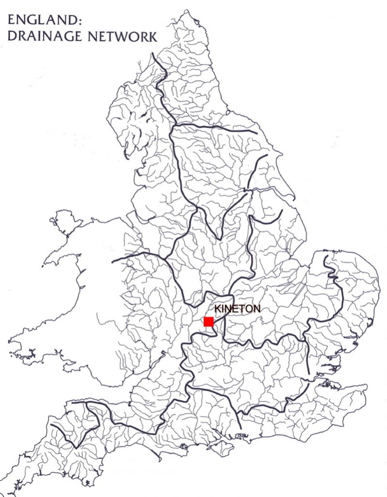
Map of the drainage and watersheds of England (based on Fig. 2.2 from B K Roberts and S Wrathmell, 2002).
Kineton is in the West Midlands, about as far from the sea as it is possible to get in the “heart of England”. The national watershed is at nearby Edgehill, where rain falling on the village road near the Castle Inn could end up flowing south and east to the Cherwell, eventually joining the Thames, or it could flow south and west down the scarp into the River Dene through Kineton, and ultimately into the Avon and Severn.
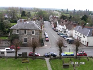 View from St Peter’s Church Tower, looking south down Bridge Street towards the River Dene.
The Cotswolds uplands form the eastern border of the area, and the contrasting ancient forest of the Arden — Shakespeare’s Arden — is to the north-west across the Avon. In between is the Feldon, an undulating landscape of fertile clay vales and limestone ridges, with Kineton in the centre, straddling the River Dene.
Prehistory
The last glaciation covered the area, smoothing the contours, and wiping out any evidence of previous human activity, except for rare stone tools rolled down in rivers and left in gravel deposits along their banks. The River Avon terraces have yielded examples of such palaeolithic (old stone age) tools. The hunter gatherers of the mesolithic (Middle Stone Age) who followed the retreating glaciers, around 9,000 years ago, are likely to have established camps along the river valleys, which seem to have been the routes by which they penetrated inland. By their very nature these tempory shelters have left little evidence, and even finds of stone tools of this period are rare in the lowlands. None are known from the Kineton area.
The first farmers of the neolithic (New Stone Age) no doubt used the area from about 4,000 years Before Common Era (BCE) to 2000BCE but evidence is rare except on the high ground of the Cotswolds where upstanding monuments still survive, and in the river gravels along the Avon, for instance at Barford. A few flints have been found around Kineton. The site of Kineton, near the stream, would have been attractive, but the clay soils may have been too heavy for the light neolithic ard (an early form of plough), and forest exploitation and animal husbandry may have been the main occupation. Similar limitations in the available evidence affect our understanding of the bronze age (c.2000BCE to 700BCE), and again more evidence is visible on the uplands and on the river gravel terraces than in the claylands. Recent research in Northamptonshire and Bedfordshire claylands has challenged the traditional view that “difficult “clay soils were virtually ignored by neolithic and bronze age farmers; there was probably mixed farming on the Feldon, albeit less intensely than on the lighter soils of the Cotswolds. There may have been bronze age burial mounds — barrows — on the scarp of Edgehill where later field names hint at lost monuments, and on Pittern Hill “Hnybba’s barrow” is mentioned in a charter of 969.
The iron age saw more intense human activity and the Cotswold scarp possibly became part of an important long distance route, the Jurassic Way, although physical evidence for this track is lacking.
The hill fort of Nadbury Camp above Arlescote is one of several strung out along this ridge, but again evidence for iron age activity in the clay vale around Kineton is lacking. Iron age pastoral farming was almost certainly proceeding in the area, however. Two iron age tribes of central England, the Dobunni to the south west and the Coritani to the north west, appear to have established a more or less disputed frontier running down the Edgehill scarp across the Feldon to the Avon, creating a frontier zone which included Kineton and district. A relic of these pre-Roman peoples may survive in the name of Brailes, which may contain the early celtic word “bre” – “hill” – very appropriate for the steep sided hill which is the most prominent feature of the parish.
Roman
In the very early Roman invasion period the area was part of the militarised Plautian Frontier Zone centred on the Fosse Way, which passes within 4km of Kineton.
The Fosse Way looking north through Halford (photo English heritage)
At this time rural settlements outside towns and forts consisted of scattered farms and villas set amongst their fields. There is evidence that the area was reasonably well occupied in the later Roman period, with many farms and small settlements being found through fieldwalking and metal detecting on the slopes of the Cotswolds and through increasing finds of Roman material from the Feldon. A small Romano-British farm existed about a kilometre east of Kineton village, and a villa is known from aerial photographs and finds at Brookhampton to the south west. Another prestigious villa with mosaics has been found at Pillerton Priors. Some of the produce of these farms would no doubt have been transported to other part of Britain, and possibly to further parts of the Roman Empire, along the Fosse Way.
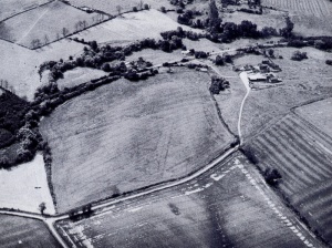
Brookhampton Roman villa shows as cropmarks in the field to the left of the farmhouse (Figure on page 2 of Kineton: the Village and its History)
The relatively efficient transport links of the Roman Empire can be seen in the evidence from Roman domestic sites, which are usually characterised by copious quantities of well-made pottery, some from industrial-scale potteries in Oxfordshire, north Warwickshire and Northamptonshire, together with high-class imported pottery from Gaul. No concentrations of such material has yet been discovered in Kineton village.
Early medieval
After the Romans left the Britons to their own devices in 410CE, pagan north European settlers (“Saxons”) arrived and began to stamp their culture on England. It is still debated whether there was a wholesale replacement of the British population by Germanic peoples or whether the newcomers merely took over the .reigns of power. Early Saxon cemeteries can be rich sources of information and a cemetery spanning the late Roman and early Saxon period was recently excavated at Wasperton north of Stratford upon Avon, and is interpreted as demonstrating a degree of co-existence between the British and the newcomers. A pagan Saxon cemetery on Pittern Hill about a kilometre north of the village is the only material evidence of their presence in the immediate locality. More evidence of the pagan influence of the incomer’s culture comes from the place name Tysoe, meaning (the god) Tiw’s Hill, referring to one of the spurs of the Cotswold scarp above Tysoe village. Other place-names suggest that the surviving pre-Saxon Romano-British population was recognised as a distinct component of the ethnic mix — Wellesbourne and Walton both contain the element wahl meaning “welshman”, ie British.
The Mercian tribe occupied the area to the north-east of Kineton, with the Hwicce (who gave their name to Wychwood and Worcester) to the south-west, probably along a frontier very similar to the earlier iron age tribal boundaries. Physical remains of Saxon activities are very difficult to detect, their domestic buildings being made of wood, with some partially sunk into the ground, and for the middle part of the period in this area pottery was not a common material and what there is, is very fragile and easily disintegrates in the ground. Even in the later Saxon period, before the Norman conquest, the only stone buildings in the countryside would have been churches, and not all of them. The raised, circular churchyard of All Saints, Chadshunt, together with the nearby “Ceadel’s spring” (Ceadel’s funta) recorded in a document dated 949 suggests that there was a pre-conquest church on the site, but no other traces of the period have been found here. The funta part of the name comes from Latin, and suggests that there was some continuity from Romano-British times.
Sometime between the end of the Roman period and the 11th century a village had grown up at Kineton, and around it were smaller hamlets and villages, Chadshunt, the Comptons (Verney and Wynyates), Gaydon, the Pillertons (Hersey and Priors), Tysoe, Radway, Butlers Marston, Ratley and the other nearby settlements noted in the Domesday Survey of 1086. There had clearly been a profound change in the landscape, with the dispersed farms of the Roman and early Saxon period set within their small individual fields, now replaced by clusters of farm buildings in nucleated settlements – villages – surrounded by a few very large fields.
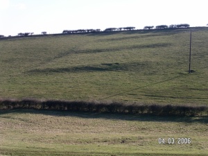
Ridge and furrow with the characteristic reverse ‘S’ shape near Arlescote.
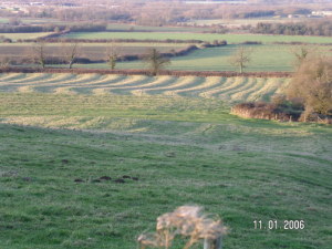 These fields were divided into long narrow strips, which were grouped into furlongs, and collections of furlongs made up the large fields. There were few hedges, the divisions between the strips being marked by the way the plough heaped up the soil towards the centre of each strip, to make the “ridge and furrow” corrugations that can still be seen, especially near the scarp slopes. By the late Saxon period the Feldon was arable country, the “champion” cultivated land. The late Saxon estates established in the Feldon, where woodland and forage was already scarce, seem to have compensated for this through links with woodland areas in the Arden, north of the River Avon. Brailes, for instance was linked to Tanworth in Arden, and Tanworth parish was a detached part of Fexhole Hundred comprising much of south east Warwickshire. The modern pattern of roads and tracks from the Feldon across the Avon into the Arden retains a hint of these links.
The Domesday Survey
From later in the Saxon period we have a charter of 969 from King Edgar to a nobleman called Alfwold giving land in Cynton (=King’s settlement/farm). The grant shows that the land was owned by the King and possibly contained a village. The charter boundaries appear to be very similar to those of the present parish, although some interpretations see it as including the adjacent Combroke. By the time of the 1086 Domesday survey, Quintone, as Kineton was then spelled, was still owned by the King (one of only nine royal holdings in Warwickshire), and, together with Wellesborne, was assessed at only 3 hides, although a total of 38 plough teams are listed. With more than 100 villagers and smallholders (and 5 slaves) Kineton, together with Wellesbourne, was smaller than nearby Brailes (130 villagers and smallholders) but three times the size of Butlers Marston with 32 villagers and smallholders. Unfortunately no cash valuation is given for Kineton with Wellesbourne, but Tysoe was valued at £30 with 32 ploughs and 81 villagers and smallholders, and Brailes at £50 with 60 ploughs and 130 villagers and smallholders. The smallest Domesday assessment in our area was for Compton Verney (simply named Contone in the Domesday Book), which listed 17 villagers and smallholders worth £4.00, followed by Ratley (with 25 people, and valued at £5.00), which gives us an idea of the relative values put on the settlements in the area.
Several Domesday manors were held, or had been held by women in their own right. Part of Radway was held from the Church of Coventry by Ermenfrid, who also held land in Ladbroke, Calcutt, Ashow, Radford Semele, Ettington and Fulready. Part of Walton was held before the conquest by two women, Gytha and Saeith. Interestingly Gytha is a Norse name and Saeith is a Saxon one, and the Kineton area was between the Norse Danelaw to the east and the Saxon kingdoms to the west; this combination of women with Norse and Saxon names neatly illustrates the probable ethnic mixture in the area. Christina (grand daughter of King Edmund Ironside) had considerable holdings in Long Itchington, as well as land in Ulverley and Arley. Several Warwickshire manors were held by women but listed by reference to their relation to a man, such as Leofwin of Newnham’s mother who held Mollington before the conquest, and Adelaide, Hugh of Grandmesnil’s wife, who held part of Middleton, another part of which was held by Hugh himself (Hugh of Grandmesnil was also lord of the manors of Pillerton Hersey, Butler’s Marston, and Oxhill, as well as having extensive holdings elsewhere in Warwickshire). Lady Godiva, widow of Earl Leofric, also held considerable land. It has been argued that the formal status of women took a turn for the worse after the conquest, although individuals still made their mark.
Kineton, Idlicote, Whatcote, Oxhill, Tysoe, Honington and Brailes formed the Domesday Hundred of Fexhole, but in the 12th century the Domesday Hundreds of Fexhole, Tremlow, Hunsbury and Barcheston were amalgamated into Kineton Hundred, encompassing most of the south eastern part of Warwickshire.
Medieval (1066–1485)
In the early 12th century King Henry I gave the Church of St Peter and land in Little Kineton to Kenilworth Priory, starting a division that persists to this day. King John (1199–1216) gave the manor of Kineton Magna (variously spelled Kyneton, Kyngton, Chipping Kyneton) to Stephen Seagrave, a nobleman who had supported him during the Barons Revolt. The motte and bailey castle overlooking the River Dene to the west of the village , now known as King John’s Mound, may date to this unsettled period, although it may equally relate to the unrest in the time of King Stephen (1135–1154) half a century earlier. persOther small castles in the area — Brailes, Halford and Ratley for instance — are similarly characteristic of the defensive precautions taken by local warlords around the country.
